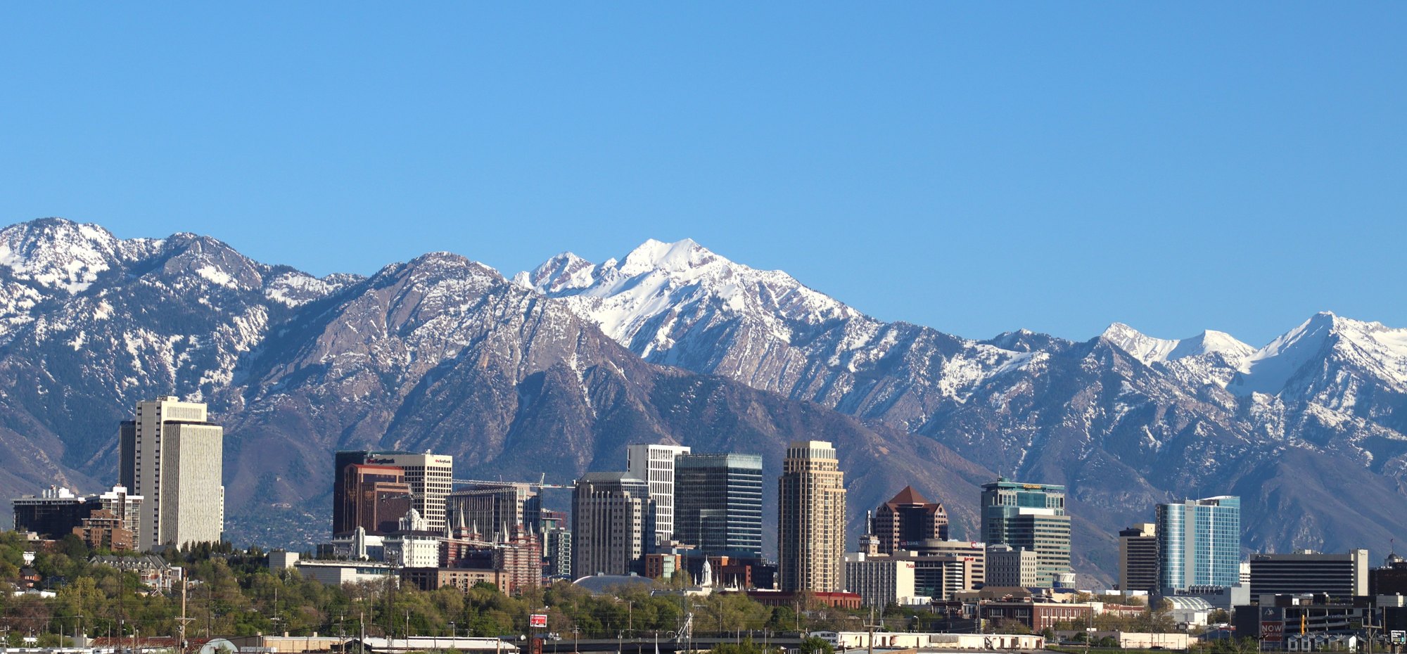
Salt Lake City and the Wasatch foothills

Outdoors

Fishing near Salt Lake City

Lakes, rivers and recreation areas near Salt Lake City where fishing is allowed, closest first.

23places to fish
11 mito the closest
17within 30 miles

Good to know: Anyone 16 or older generally needs a state fishing license; seasons, limits and special rules vary by water. Utah license information ↗

Closest picks

1

Dogwood Day Use

11 mi southeast · USDA Forest Service

Dogwood Day Use Picnic Area is just 2 miles up Big Cottonwood Canyon, conveniently close to Salt Lake City. Big Cottonwood Creek runs alongside the site. Visitors enjoy fishing, hiking and biking.
2

Storm Mountain Day Use Area

12 mi southeast · USDA Forest Service

Storm Mountain Day Use Area is just 3 miles up Big Cottonwood Canyon, conveniently close to Salt Lake City. Big Cottonwood Creek runs alongside the site. Visitors enjoy fishing, hiking and biking.

3

Jordan Pines

15 mi southeast · USDA Forest Service

Jordan Pines Campground is located in scenic Big Cottonwood Canyon at an elevation of 7500 feet. Salt Lake City is conveniently close. Visitors enjoy hiking, biking and fishing.

Map of all 23 places

Map of 23 places loads as you scroll.

Within 30 miles (17)

11 mi southeast · USDA Forest Service · Campground

Dogwood Day Use

Dogwood Day Use Picnic Area is just 2 miles up Big Cottonwood Canyon, conveniently close to Salt Lake City. Big Cottonwood Creek runs alongside the site. Visitors enjoy fishing, hiking and biking.

  • Biking
  • Camping
  • Climbing
  • Fishing
  • Hiking
  • Picnicking
  • Scenic Drive

12 mi southeast · USDA Forest Service · Campground

Storm Mountain Day Use Area

Storm Mountain Day Use Area is just 3 miles up Big Cottonwood Canyon, conveniently close to Salt Lake City. Big Cottonwood Creek runs alongside the site. Visitors enjoy fishing, hiking and biking.

  • Biking
  • Camping
  • Fishing
  • Hiking
  • Rock Climbing
  • Scenic Drive

15 mi southeast · USDA Forest Service · Campground

Jordan Pines

Jordan Pines Campground is located in scenic Big Cottonwood Canyon at an elevation of 7500 feet. Salt Lake City is conveniently close. Visitors enjoy hiking, biking and fishing.

  • Biking
  • Camping
  • Fishing
  • Hiking
  • Rock Climbing
  • Wildlife viewing

16 mi north · USDA Forest Service · Campground

Bountiful Peak Campground

Bountiful Peak Campground is set in an alpine basin high in the Wasatch Mountains at an elevation of 7,500 feet. Farmington, Utah, is 9 miles away. Visitors enjoy exploring local trails on foot, bike and off-road vehicles.

  • Biking
  • Camping
  • Fishing
  • Hiking
  • Mountain Biking
  • Picnicking
  • Scenic Drive
  • Wildlife viewing

16 mi southeast · USDA Forest Service · Campground

Spruces - Big Cottonwood

Spruces Campground is located in scenic Big Cottonwood Canyon at an elevation of 7,500 feet. Salt Lake City is conveniently close. Visitors enjoy hiking, biking and fishing.

  • Backpacking
  • Biking
  • Camping
  • Fishing
  • Hiking
  • Mountain Biking
  • Rock Climbing
  • Scenic Drive

16 mi southeast · USDA Forest Service · Campground

Tanners Flat

Tanners Flat Campground is located in scenic Little Cottonwood Canyon at an elevation of 7,200 feet, just 6 miles from Sandy, Utah. The canyon offers many hiking and biking opportunities.

  • Biking
  • Camping
  • Fishing
  • Hiking
  • Scenic Drive

19 mi southeast · USDA Forest Service · Campground

Albion Basin

Albion Basin Campground, just 15 miles from Sandy, Utah, is set among shady white pines and aspens in its beautiful namesake basin in Little Cottonwood Canyon at an elevation of 9,500 feet.

  • Biking
  • Camping
  • Fishing
  • Hiking
  • Wildlife viewing

19 mi northeast

East Canyon State Park

Tucked away in the mountains of northeastern Utah on the Wasatch Back, East Canyon Reservoir is a popular destination for boating, fishing, and camping that is only 45 minutes from Salt Lake.

  • Boating
  • Camping
  • Fishing
  • Hiking
  • History
  • Hunting
  • Off-highway vehicles
  • Picnicking

19 mi southeast · USDA Forest Service · Campground

Redman Campground

Redman Campground is located in scenic Big Cottonwood Canyon at an elevation of 8,300 feet. Salt Lake City is conveniently close. Visitors enjoy hiking, biking and fishing.

  • Biking
  • Camping
  • Fishing
  • Hiking
  • Mountain Biking
  • Rock Climbing
  • Wildlife viewing

20 mi northeast · Bureau of Reclamation

East Canyon Reservoir

Recreation at East Canyon Dam and reservoir, a feature of the Weber Basin Project, is managed by the Utah Division of Parks and Recreation under agreement with the Bureau of Reclamation.

  • Boating
  • Camping
  • Fishing
  • Hotel/Lodge/Resort Fs Owned
  • Picnicking
  • Recreational Vehicles
  • Water sports
  • Winter sports

23 mi southeast · USDA Forest Service · Campground

Granite Flat (Utah)

Granite Flat Campground is located a short distance up scenic American Fork Canyon, less than a mile from Tibble Fork Reservoir. Visitors enjoy fishing, canoeing and exploring local trails.

  • Biking
  • Camping
  • Canoeing
  • Fishing
  • Hiking
  • Horseback riding
  • Kayaking
  • Picnicking

24 mi southeast · USDA Forest Service · Campground

Little Mill

Little Mill Campground is located in American Fork Canyon on the banks of American Fork Creek. This popular campground is a great place to escape the hot summer days while hiking or fishing.

  • Camping
  • Fishing
  • Hiking
  • Picnicking
  • Scenic Drive
  • Wildlife viewing

25 mi east · Bureau of Reclamation

Jordanelle Reservoir

Jordanelle Dam and Reservoir, features of the Central Utah Project, Bonneville Unit , located on the Provo River about 10 miles north of Heber City, Utah at the 6,130-foot elevation. The reservoir has about 3,050 surface acres when full.

  • Biking
  • Boating
  • Camping
  • Fishing
  • Hiking
  • Horseback riding
  • Hotel/Lodge/Resort Fs Owned
  • Nature education

25 mi east · Bureau of Reclamation

Rockport Reservoir

Rockport Reservoir, Weber Basin Project , was formed by the construction of Wanship Dam on the Weber River.

  • Biking
  • Boating
  • Camping
  • Fishing
  • Hiking
  • Picnicking
  • Recreational Vehicles
  • Water sports

26 mi east

Jordanelle State Park

Nestled in the rolling mountains north of Heber City, Utah sits the beautiful Jordanelle Reservoir, fed by the Provo River and impounded by the Jordanelle Dam.

  • Biking
  • Boating
  • Camping
  • Diving
  • Fishing
  • Hiking
  • Paddling
  • Photography

26 mi east

Rockport State Park

Utah State Park: Idyllic Rockport Reservoir is about three miles long and one-half mile wide. At an elevation of over 6,000 feet, it covers more than 500 acres.

  • Boating
  • Camping
  • Fishing
  • Hiking
  • Horseback riding
  • Paddling
  • Picnicking
  • Swimming

28 mi northeast · Bureau of Reclamation

Echo Reservoir

Recreation at Echo Dam and reservoir, Weber River Project , is managed by Echo Resort under agreement with the Bureau of Reclamation.

  • Biking
  • Boating
  • Camping
  • Fishing
  • Hiking
  • Picnicking
  • Recreational Vehicles
  • Water sports

30 to 75 miles (6)

32 mi southeast · Bureau of Reclamation

Deer Creek Reservoir

Recreation at Deer Creek Dam and Reservoir, Provo River Project, is managed by the Utah Division of Parks and Recreation under agreement with the Bureau of Reclamation.

  • Biking
  • Boating
  • Camping
  • Fishing
  • Hiking
  • Picnicking
  • Recreational Vehicles
  • Water sports

32 mi southeast

Deer Creek State Park

Utah State Parks: Windsurf, boat, zip line and fish on the cool waters of Deer Creek Reservoir. The nearly 3,000-acre reservoir has predictable winds for excellent water sports and five species of sport fish.

  • Boating
  • Camping
  • Fishing
  • Hiking
  • Horseback riding
  • Hunting
  • Off-highway vehicles
  • Picnicking

34 mi north · USDA Forest Service · Campground

Anderson Cove (Uinta-Wasatch-Cache National Forest, UT)

Anderson Cove Campground is a popular facility located 10 miles east of Ogden, Utah, on the banks of Pineview Reservoir in scenic Ogden Valley. Visitors enjoy boating, fishing and swimming.

  • Boating
  • Camping
  • Fishing
  • Picnicking
  • Swimming
  • Water sports

37 mi south

Utah Lake State Park

Utah State Parks: Utah’s largest freshwater lake provides fishing access for channel catfish, walleye, white bass, black bass, and several species of panfish.

  • Boating
  • Camping
  • Fishing
  • Paddling
  • Photography
  • Picnicking
  • Water sports
  • Winter sports

39 mi east · USDA Forest Service

Uinta-Wasatch-Cache National Forest

  • Biking
  • Boating
  • Camping
  • Fishing
  • Hiking
  • Horse Camping
  • Horseback riding
  • Off-highway vehicles

44 mi west · Bureau of Land Management

Horseshoe Springs Wildlife Management Area (WMA)

Horseshoe Springs is both a Wildlife Management Area (WMA) and a historic site on the California National Historic Trail located in Skull Valley, Tooele County, Utah.

  • Fishing
  • Hiking
  • Nature education
  • Photography
  • Wildlife viewing

Distances are straight-line miles from downtown Salt Lake City. Listings come from Recreation.gov’s federal recreation database; check each official page for hours, fees, fire restrictions and closures before you go.

Get outside around Salt Lake City

Top 5 things to do in Salt Lake City, Utah! Check out my YouTube video for more! video thumbnail

THINGS TO DO · YOUTUBE SHORT

Top 5 things to do in Salt Lake City, Utah! Check out my YouTube video for more!

A local activity Short shared by Mahna Ghafori.

Watch on YouTube ↗

Around Salt Lake City

Capitol Theater Salt Lake City
Capitol Theater Salt Lake City 005claralieu · CC BY 2.0
Bus stands at Ballpark station, Salt Lake City, Utah
Bus stands at Ballpark station, Salt Lake City, Utah, Oct 16An Errant Knight · CC BY-SA 4.0
Commercial Club Building, Salt Lake City
Commercial Club Building (1)Tamanoeconomico · CC BY-SA 4.0

More outdoors near Salt Lake City

Questions

Where is the closest place for fishing near Salt Lake City?

Dogwood Day Use (USDA Forest Service), about 11 miles southeast of Salt Lake City as the crow flies. Next are Storm Mountain Day Use Area (12 mi) and Jordan Pines (15 mi).

Do I need a fishing license near Salt Lake City?

Yes, anglers 16 and older generally need a Utah fishing license from the state wildlife agency. Rules, seasons and limits vary by water.

Who manages these places?

Federal agencies including USDA Forest Service, Bureau of Reclamation, Bureau of Land Management. Each listing links to its official page for hours, fees, closures and current conditions.

Salt Lake City AI

Your Salt Lake City local guide
Hey there!

I'm Salt Lake City AI. Ask about neighborhood food, independent shops, local history or planning a visit.

AI recommendations may be inaccurate. Verify hours and prices. Questions are processed by Cloudflare. Privacy